Forest Monitoring
Ensure EUDR Compliance with Geospatial Intelligence
Leverage advanced geospatial intelligence to monitor, report, and ensure deforestation-free supply chains.
What is the EU Deforestation Regulation (EUDR)?
The EUDR mandates that companies placing certain commodities—such as soy, beef, cocoa, palm oil, coffee, rubber, and wood—on the EU market must prove these products are not linked to deforestation post-December 31, 2020. Compliance requires:
-
Collecting geolocation data of production areas
-
Conducting thorough risk assessments
-
Implementing risk mitigation strategies
-
Submitting annual due diligence statements
Non-compliance can result in fines up to 4% of annual EU turnover and market access restrictions.
How Rezatec Supports Your Compliance Journey
Our solutions transform how you prioritize, plan, and optimize investments in your supply chain.
Proactive Monitoring of Land Use Changes
Rezatec leverages high-resolution satellite data to continuously monitor land use, enabling you to swiftly detect any signs of deforestation within your supply chain. Our monitoring solutions provide detailed insights, ensuring you remain informed and can proactively address potential compliance issues.
Comprehensive Risk Assessment
Our advanced geospatial intelligence enables detailed risk assessments across your entire supply chain. Rezatec accurately identifies regions with higher deforestation risks, helping your organization prioritize resources effectively and maintain robust compliance with EUDR guidelines.
Reliable Validation of Compliance
Rezatec’s solutions deliver verifiable evidence to demonstrate your supply chain’s alignment with EUDR standards. Our analytics tools produce accurate, transparent documentation confirming that your commodities originate from deforestation-free sources, simplifying compliance reporting and audits.
Optimized Resource Management
By pinpointing areas that require immediate attention—such as reforestation or improved land management—Rezatec empowers you to allocate resources efficiently. Our analytics-driven insights help optimize your interventions, reducing operational costs while strengthening your sustainability commitments.
Key Advantages of Our Solution
Why Choose Rezatec?
High-Resolution satellite monitoring
Track forest health and land use changes in near real-time
Risk assesment tools
Identify and evaluate deforestation risks across supply chains.
Resource optimization and cost savings
Target specific areas for intervention, reducing operational costs
Compliance Reporting
Generate reports aligned with EUDR requirements.
Rezatec Geospatial Platform
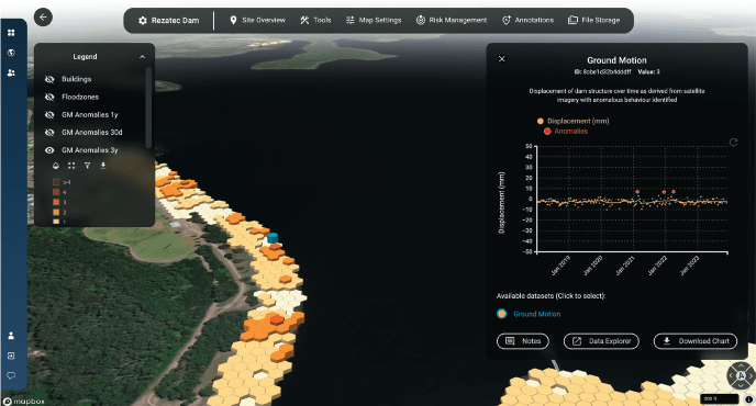
Quick to sign up, and easy to add your data, our platform gives you 24/7 secure access to your data from anywhere. The platform features advanced visualisations that allow you to map, analyse, and interpret your insights with ease. Powerful interactive tools enable you to explore, filter, and interrogate your data, helping you make informed decisions with greater accuracy and confidence.
- Data overlaid on maps
- Compare data geosptially and over time in charts
- Filter and sort tables to identify the plots you need to visit
- Integrate seismic, weather and wild-fire alerts
- And more…
Satellite-based insights
Using multispectral data from satellites, Rezatec’s model identifies spectral indices of forested and vegetated areas on the ground. The archived satellite data ensures Rezatec’s models can incorporate historical datasets and use data science to identify trends and seasonal patterns in the data and any significant negative changes in the state of the canopy cover. Frequently refreshed data from each orbit every 5-12 days facilitates remote monitoring of the changing state of the forested assets over time.

Explore Our Inights on Geosaptial Anayltics
Trusted Globally for Forest Monitoring
“New Forests requires accurate and precise forest inventory to quantify climate benefits from managing forests sustainably. Rezatec’s platform provides improved efficiency in field data collection, resulting in timely, accurate and spatially resolved results that meet our due diligence and business development needs.”
Peter Tittman, Investments Analytics Manager, New Forests.
“Forsite is really excited about the innovative capabilities that satellite data can now provide to the forestry sector … we can enable our clients to be more productive, more efficient and more profitable”
Cameron Brown, Forsite Consultants
“Rezatec provides the ideal remote sensing tool to capture robust metrics for canopy connectiveness, helping us measure how the project is improving nature across a wide area for the long term”
Annie Murray, National Trust

Speak to us today
Our team is here to answer your questions. We’re excited to help you explore how geospatial analytics can support your business. Just fill out the form and we’ll get back to you.
