Dam Monitoring
Enhance Hydro Dam Safety and Performance with Geospatial Analytics
Managing Structural and Regulatory Risks in Hydroelectric Dams
Managing hydroelectric dams requires navigating complex structural, environmental, and regulatory challenges. Each dam is unique, often with aging infrastructure and increasing risks driven by climate change and unpredictable water patterns. Rezatec’s Dam Monitoring solution supports safer, more effective management by enhancing structural integrity monitoring and ensuring regulatory compliance.
Smarter insights, proactive maintenance, safer hydro operations
Rezatec’s Dam Monitoring enhances your existing monitoring practices with deeper, actionable insights. Our scalable, satellite-driven solution simplifies remote monitoring by providing detailed historical and ongoing data on structural movement, seepage, and vegetation—often at the equivalent cost of just one or two sensors. Free your engineers for critical onsite tasks while our platform helps you effectively manage dam safety risks and optimize your operational resources
Structural Deformation
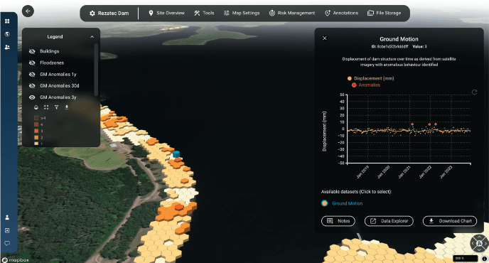
Hydroelectric dams face continuous stress from water pressure, environmental conditions, and as an aging infrastructure this could potentially leading to subtle structural movements. Rezatec’s dam monitoring solution uses InSAR satellite data and proprietary processing to identify small, incremental deformation early, enabling hydro dam operators to proactively manage risks and address structural concerns before they escalate into costly and hazardous situations.

Regulatory Compliance
Hydropower operators must comply with stringent national and regional standards from bodies such as FERC. Each dam needs an Emergency Action Plan, which has been tested and communicated to downstream communities. Rezatec’s Dam Monitoring solution can monitor buildings and addresses in the downstream floodzone and data can easily be filtered, reviewed and exported into your reports.
Operational Efficiency
Routine inspections and reactive maintenance can be costly and disruptive for hydroelectric operations. Rezatec’s solution allows operators to prioritize maintenance activities. By centralizing their data in our digital dam record and enhancing than with ongoing and historical data on movement and vegetation from satellites will significantly reduce unnecessary time spent analyzing data and planning. By making better use of their data and creating new insights, operators can ensure assets remain safe, compliant, and operationally effective.
Key Advantages of Our Solution
Comprehensive Hydro Dam Monitoring
Trusted by hydropower operators globally, Rezatec’s Dam Monitoring centralizes your dam record and enhances your existing monitoring with deeper insights. This scalable solution saves time by streamlining data analysis, providing historical and ongoing movement and seepage data at the cost of just one or two sensors. Free up your engineers for critical tasks while our platform helps you manage and maximize your data.
Risk-Focused Compliance
Aligns monitoring practices with regulatory standards, enhancing dam condition monitoring and streamlining Emergency Action Plan updates.
Proactive Detection
Enables early detection of potential issues, allowing for timely interventions and reducing the risk of dam failure.
Cost Efficiency
Delivers high-quality insights at a fraction of the cost of traditional monitoring methods, optimizing resource allocation.
Integrated Satellite and Ground Data
Our solution combines satellite imagery with ground-based data to provide a holistic view of dam health, ensuring no detail is overlooked.
Enhanced Data Visibility
Centralizes all dam-related data into one accessible platform, improving decision-making and collaboration.
Scalable Solutions
Our platform grows with your needs, accommodating expanding infrastructure and increasing data volumes seamlessly.
Trusted Globally for Dam Management
“Rezatec’s Analytics platform gives us more information about the dam than we would otherwise have access to, that helps us build the investment story for decision makers. Our recommendations are based on fact and objective data, which bolsters the case for them.”
Jeanne Finger, Chief Dam Safety Engineer, City of Spokane
“The more information we have the better it helps us prepare and plan for when we actually do need to spend that money for any necessary repairs and improvements. The data provided by Rezatec will allow us to cost-effectively monitor our dams.”
Billy Cothran, Chief Executive Officer, SJWD
“Rezatec are continuously improving the Dam Monitoring solution and I’m impressed with these latest enhancements which are driving us in the way we use data and what to focus on. At Hunter Water we are confident we are doing everything in our power to exceed regulatory requirements and safeguard our dams and the surrounding population.”
Dan Turnbull, Dam Safety Engineer, Hunter Water
Rezatec Geospatial Platform
Quick to sign up, and easy to add your data, our platform gives you 24/7 secure access to your data from anywhere. The platform features advanced visualisations that allow you to map, analyse, and interpret your insights with ease. Powerful interactive tools enable you to explore, filter, and interrogate your data, helping you make informed decisions with greater accuracy and confidence.
- Manage files and data
- Notify and message your colleagues
- Compare data geospatially and in normalised charts
- Integrate seismic, weather and wild-fire alerts
- And more…

Satellite-based insights
Analyse historical events with retrospective data, or use that past data to give you a benchmark for identifying future events ahead of time. Our dam-specific earth observation methods analyse satellite data to provide consistent, regular, remote data accessible from your desk.
Movement – Using InSAR, Rezatec’s Dam Monitoring provides ground motion analysis across your entire dam retrospectively, with monthly updates to keep you informed of changes. The solution uses data analysis to identify potential issues where patterns are outside the seasonal norm or trend in data. As the radar wave is short, the changes detected are at a millimetric level, helping you identify issues that may not yet be visible to the eye.
Seepage – Multispectral data from satellite can identify the moisture and vigor or greenness of the ground. Data analysis of historical changes in both these indices means you can identify potential seepage where there are readings outside the seasonal norm, or an increase in trend. It may pick up something new not visible to the eye or it may provide data on an area you already know allowing you to measure it.
Explore Our Insights on Geospatial Analytics

Speak to us today
Our team is here to answer your questions. We’re excited to help you explore how geospatial analytics can support your business. Just fill out the form and we’ll get back to you.

