InSAR + Geospatial Insights
Satellite Monitoring and Risk Detection for Oil & Gas Infrastructure
Monitor Infrastructure Risk from Space—Track Ground Movement and Detect Buried Pipeline Hazards Using InSAR Satellite Data and Geospatial Intelligence
Ground Movement Detection with Satellite Precision
In the oil and gas sector, protecting tanks, refineries, and buried pipelines from external risks is critical. Rezatec provides two complementary technologies that deliver early warning before damage occurs.
Rezatec’s InSAR technology detects millimeter-scale ground movement beneath tanks and facilities, identifying subsidence, uplift, and instability without field crews or onsite equipment. Updated every 6–12 days, InSAR delivers both historical trends and near real-time insights into terrain shifts and foundation health. For buried pipelines, Rezatec applies geospatial intelligence and machine learning to analyze pipeline attributes alongside environmental factors like slope, vegetation, ground movement, and soil composition. This predictive modeling highlights where external forces increase failure risk, allowing asset integrity teams to take proactive action before internal indicators surface.

Enhanced Asset Management
Rezatec’s two solutions help operators monitor both above-ground and buried infrastructure.
For tanks, terminals, and facility foundations, Rezatec’s InSAR solution continuously monitors ground movement and detects early signs of instability, allowing teams to intervene before damage threatens foundations, tank alignment, or structural integrity.
For buried pipelines, Rezatec’s machine learning model combines InSAR-derived movement data with environmental factors—including slope instability, vegetation anomalies, and soil properties—to calculate the likelihood of external pipeline failure. Additionally, using multispectral data, the platform detects vegetation stress and surface movement anomalies that may signal developing gas or liquid leaks—even before these leaks are visible at the surface.
Reduce operational costs
Rezatec reduces costly field inspections for both tanks and pipelines by providing continuous, remote monitoring. For tanks, operators detect foundation issues early, avoiding expensive repairs or unplanned downtime. For pipelines, predictive geospatial modeling allows operators to focus inspections on the most at-risk segments, preventing failures while optimizing maintenance resources. This proactive approach lowers operational expenses while improving long-term asset resilience.
Protect Critical Infrastructure
Ground movement is one of the earliest indicators of instability. InSAR delivers continuous movement detection around tanks and facilities, allowing asset integrity teams to take preventive action before deformation affects storage safety or operational uptime.
For buried pipelines, Rezatec’s geospatial intelligence provides insight into the environmental forces acting on the pipe system. By identifying slope creep, unstable soils, or vegetation shifts that may indicate underground leaks, operators gain the ability to mitigate risk far earlier than pressure monitoring or inline inspection alone can achieve.
Enable Long-Term Infrastructure and Environmental Planning
Rezatec helps operators manage facility growth, decommissioning, or regulatory reporting with confidence. For tanks and facilities, long-term ground movement data supports expansion projects, foundation management, and environmental stability. For buried pipelines, terrain modeling informs routing, construction, and asset retirement planning based on localized geotechnical risk. Both solutions strengthen ESG reporting and compliance obligations while supporting responsible operational planning.
Key Advantages of Our Solution
Surface Deformation Monitoring for Oil & Gas Infrastructure Using InSAR Technology
Rezatec equips oil and gas operators with the tools to understand and monitor ground movement beneath tank farms and fixed site infrastructure. Our millimeter-accurate InSAR platform identifies subtle shifts in ground stability across multiple locations, eliminating the need for manual field inspections. For pipelines, geospatial risk modeling layers machine learning over environmental data to forecast failure risk, detect vegetation stress, and highlight emerging surface disruptions that signal developing leaks—all from space, without on-site hardware.
Early detection
Catch subsurface ground movement or vegetation anomalies before they evolve into costly structural or environmental failures
Wide-area, scalable coverage
Monitor tank farms and buried pipelines across vast geographies without deploying field crews or equipment
Historical insight
Analyze long-term movement patterns using archived satellite data for smarter planning and root-cause analysis
Millimeter-scale accuracy
Detect the smallest shifts with unmatched precision—enabling early intervention and structural protection
Proven & Trusted
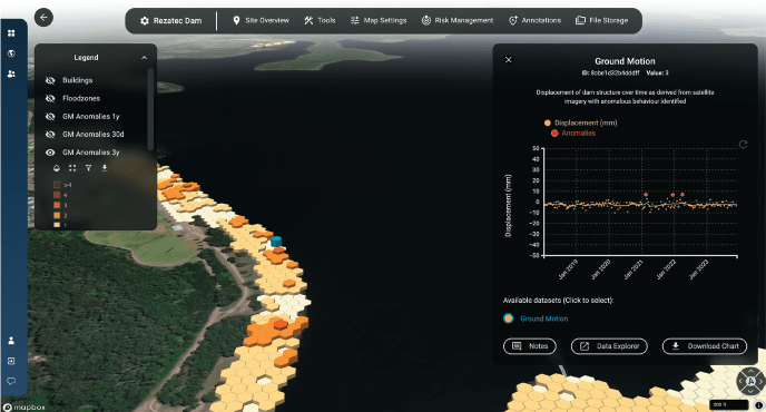
Rezatec’s method for InSAR processing has been validated against GNSS and GPS data demonstrating consistently accurate results. InSAR-based ground deformation monitoring uses radar satellite imagery to detect and measure subtle movements of the Earth’s surface over time. This is achieved by analysing the phase difference between multiple radar images taken from the same location in space at different times. By carefully selecting persistent and distributed reflectors, the technique isolates true ground motion from atmospheric noise and other distortions, enabling millimeter-level accuracy. The result is a time series of vertical displacements across a wide area, making it a powerful tool for identifying long-term trends or sudden shifts in ground stability.
Rezatec Geospatial Platform
Quick to sign up, and easy to add your data, our platform gives you 24/7 secure access to your data from anywhere. The platform features advanced visualisations that allow you to map, analyse, and interpret your insights with ease. Powerful interactive tools enable you to explore, filter, and interrogate your data, helping you make informed decisions with greater accuracy and confidence.
- Record notes geospatially
- Notify and share across colleagues
- Compare data geospatially and temporally
- Integrate seismic, weather and wild-fire alerts
- And more…

Explore Our Insights on Geospatial Analytics

Speak to us today
Our team is here to answer your questions. We’re excited to help you explore how geospatial analytics can support your business. Just fill out the form and we’ll get back to you.


