Water utilities are under more pressure than ever. Aging networks, more extreme weather patterns, and mounting regulatory expectations are all converging at once. Meanwhile, budgets remain tight and teams are being asked to do more with less.
Despite all this, many utilities are still working with tools and models built for a different operational reality.
- Break history and pipe age dominate risk decisions—but tell only part of the story
- Leak detection relies heavily on miles walked rather than data-led targeting
- Replacement budgets stretch to just 0.5–1% of total network length per year
- Emergency repairs continue to consume resources that could be invested proactively
The real shift underway? Moving from historical reporting to geospatial intelligence that predicts failure before it happens.

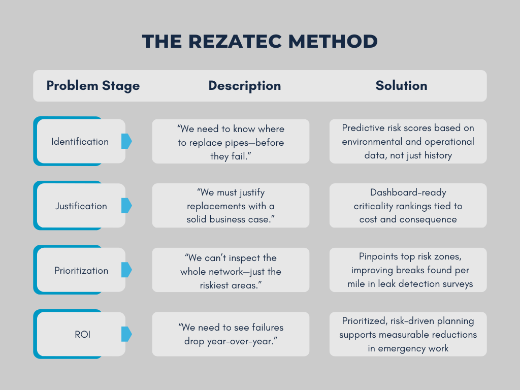
The Rezatec Approach to Geospatial Analytics
From Guesswork to Geo-Intelligence: A Smarter Way Forward
Legacy risk models were never designed to factor in environmental stress, land movement, or climate-driven variables. But today, these external forces are proving to be major contributors to pipeline failure—and ignoring them means missing critical risk signals.
The new standard emerging across the industry is clear:
Layer multiple data types—internal network records, environmental context, and satellite-derived insights—to generate hyper-precise risk profiles.
How Modern Geospatial Intelligence Changes the Game
When water utilities combine network data with environmental factors and machine learning, operational decision-making transforms from reactive to predictive.
This next-generation approach brings together:
- Environmental signals like soil type, slope, vegetation stress, and ground motion
- Internal GIS and asset records, including install year, material, and historical breaks
- Satellite intelligence for continuous, network-wide surveillance without physical inspection
The result? Accurate, pipe-level risk scores that highlight where to act first—and why.
Real Utility Impact: What the Data Shows
Utilities adopting geospatial intelligence aren’t just improving visibility—they’re changing outcomes in the field.
In recent deployments:
- 93% of recorded breaks were located within the highest 20% risk-ranked pipe segments
- 62% of total water loss occurred in just the top 10% of risk areas
- Leak detection teams achieved 5x more breaks found per mile walked, thanks to targeted risk zones
This kind of precision doesn’t just sharpen planning—it builds confidence across leadership, engineering, finance, and field teams.
Case Example: City of Olathe Moves to Predictive Modeling
The City of Olathe, Kansas—managing over 850 miles of water network—needed a scalable way to plan ahead, justify spend, and transition from reactive maintenance.
By bringing satellite-derived environmental intelligence into their internal GIS data, Olathe was able to:
- Build a dynamic Likelihood of Failure model covering their entire network
- See exactly which pipes were most at risk—before failure
- Confidently prioritize capital programs with defensible insights
- Stretch limited budget further without compromising service.
“We were looking for a way to really quantify where our problems were coming from and to identify where to go next. Rezatec helped us make those decisions faster and with more confidence.” — Sabrina Parker, Water & Sewer Manager, City of Olathe. Read Full Case Study here
The Future of Pipeline Management Is Intelligence-Led
As water utilities navigate ageing assets, heightened climate stress, and rising accountability, one thing is clear: historical-only models can’t keep pace with today’s risk landscape.
Geospatial intelligence offers a proven, scalable path toward proactive, data-driven pipeline decisions that save cost, reduce water loss, and improve public trust.