
InSAR + Geospatial Insights
Satellite Monitoring and Risk Detection for Oil & Gas Infrastructure
Repeatably monitor pipeline corridors and tank farms with satellite-derived InSAR analytics. Detect emerging ground movement, prioritize inspections, and focus engineering where changing conditions warrant it.
Ground Movement Detection with Satellite Precision
In the oil and gas sector, protecting tanks, refineries, and buried pipelines from external risks is critical. Rezatec provides two complementary technologies that deliver early warning before damage occurs.
Rezatec’s InSAR technology detects millimeter-scale ground movement beneath tanks and facilities, identifying subsidence, uplift, and instability without field crews or onsite equipment. Updated every 6–12 days, InSAR delivers both historical trends and near real-time insights into terrain shifts and foundation health.
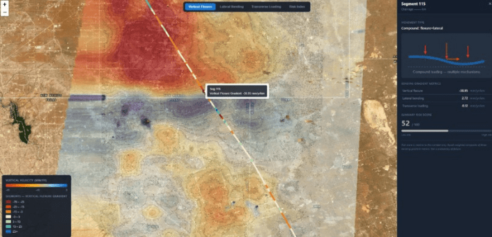
For buried pipelines, repeat Sentinel-1 observations are combined with pipeline geometry and segmented (typically 500 m) to produce three ground-movement indices: Vertical Flexure, Lateral Bending and Transverse Movement. This gives integrity teams an objective, corridor-wide view of where changing ground conditions may warrant closer inspection or engineering review.
Enhanced Asset Management
Rezatec’s two solutions help operators monitor both above-ground and buried infrastructure.
For tanks, terminals, and facility foundations, Rezatec’s InSAR solution continuously monitors ground movement and detects early signs of instability, allowing teams to intervene before damage threatens foundations, tank alignment, or structural integrity.
For buried pipelines, Rezatec converts satellite-detected ground displacement into segment-level movement indicators across the corridor. This gives integrity teams a repeatable, objective view of where subsidence, heave or lateral movement is developing, complementing in-line inspection (ILI) and geotechnical programs between costly runs and patrols.
Reduce operational costs
Rezatec reduces costly field inspections for both tanks and pipelines by providing continuous, remote monitoring. For tanks, operators detect foundation issues early, avoiding expensive repairs or unplanned downtime. For pipelines, corridor-wide screening lets operators focus inspections and integrity-dig spend on the small subset of segments showing the most ground movement, optimizing maintenance resources.


Protect Critical Infrastructure
Ground movement is one of the earliest indicators of instability. InSAR delivers continuous movement detection around tanks and facilities, allowing asset integrity teams to take preventive action before deformation affects storage safety or operational uptime.
For buried pipelines, repeatable ground-movement screening highlights where subsidence, heave or lateral displacement is emerging along the corridor, giving operators corridor-wide awareness far earlier than periodic visual patrol alone.
Enable Long-Term Infrastructure and Environmental Planning
Rezatec helps operators manage facility growth, decommissioning, or regulatory reporting with confidence. For tanks and facilities, long-term ground movement data supports expansion projects, foundation management, and environmental stability. For buried pipelines, terrain modeling informs routing, construction, and asset retirement planning based on localized geotechnical risk. Both solutions strengthen ESG reporting and compliance obligations while supporting responsible operational planning.

Proven & Trusted
Rezatec’s method for InSAR processing has been validated against GNSS and GPS data demonstrating consistently accurate results. InSAR-based ground deformation monitoring uses radar satellite imagery to detect and measure subtle movements of the Earth’s surface over time. This is achieved by analysing the phase difference between multiple radar images taken from the same location in space at different times. By carefully selecting persistent and distributed reflectors, the technique isolates true ground motion from atmospheric noise and other distortions, enabling millimeter-level accuracy. The result is a time series of vertical displacements across a wide area, making it a powerful tool for identifying long-term trends or sudden shifts in ground stability.
Key Advantages of Our Solution
Surface Deformation Monitoring for Oil & Gas Infrastructure Using InSAR Technology
Rezatec equips oil and gas operators with the tools to understand and monitor ground movement beneath tank farms and fixed site infrastructure. Our millimeter-accurate InSAR platform identifies subtle shifts in ground stability across multiple locations, eliminating the need for manual field inspections. For pipelines, the same InSAR analytics are applied along the corridor and segmented into Vertical Flexure, Lateral Bending and Transverse Movement indices, highlighting where ground movement may be loading the pipe, all from space and without on-site hardware.
Early detection
Catch emerging ground movement before it evolves into a costly structural or integrity failure
Wide-area, scalable coverage
Monitor tank farms and buried pipelines across vast geographies without deploying field crews or equipment
Historical insight
Analyze long-term movement patterns using archived satellite data for smarter planning and root-cause analysis
Millimeter-scale accuracy
Detect the smallest shifts with unmatched precision—enabling early intervention and structural protection
Built for US Regulatory Requirements
49 CFR §192.917 and §195.452 require gas and hazardous-liquid operators to identify, evaluate, and mitigate earth-movement threats as part of their integrity management programs. Recurring PHMSA advisory bulletins increasingly call for quantitative, repeatable geohazard evidence, not just periodic visual patrol. Rezatec gives your team a documented, corridor-wide basis for meeting these obligations.
What You Get
- Vertical Flexure, Lateral Bending & Transverse Movement indices per segment
- Hazard Summary Score and Action Class (Stable / Monitor / Investigate)
- Data Quality Grade per segment
- Segment scorecards with chainage & movement type
- Interactive web viewer with clickable, color-coded corridor map
- GIS-ready shapefiles, GeoTIFFs, and CSV exports
- Annual, quarterly, or monthly delivery cadence
Explore Our Insights on Geospatial Analytics
Frequently Asked Questions
What is Rezatec's Oil & Gas Infrastructure Monitoring?
Rezatec uses satellite data to catch ground-movement risks to tanks and buried pipelines early. InSAR measures millimeter-scale movement under tanks. Along the pipeline corridor, it becomes segment-level movement indices. No crews, no on-site equipment.
What does Rezatec monitor for oil and gas operators?
Rezatec monitors both above-ground and buried infrastructure from satellite data. For tanks, terminals and facility foundations it tracks ground movement and early signs of instability; for buried pipelines it predicts where environmental forces increase the likelihood of external failure — all without field crews or on-site equipment.
How does InSAR detect ground movement under tanks and facilities?
InSAR compares radar satellite images taken over the same spot at different times and measures the phase difference between them. Stable reflectors, like tanks, buildings and hard ground, let it separate real ground motion from atmospheric noise. The result is a millimeter-accurate history of how the surface is moving, showing subsidence, uplift and instability over time.
How often is Rezatec's satellite monitoring updated?
Rezatec’s InSAR monitoring refreshes every 6 to 12 days, giving you both long-term movement trends and a near real-time view of ground shifts around your assets.
How does Rezatec monitor buried pipelines?
Rezatec tracks ground movement along the whole pipeline corridor from satellite data. The corridor is split into segments (typically 500 m), and each one gets three movement scores: Vertical Flexure, Lateral Bending and Transverse Movement. Every segment is flagged Stable, Monitor or Investigate, so your team knows where to look first.
How accurate is Rezatec's InSAR monitoring?
Rezatec’s InSAR is accurate to the millimeter and validated against GNSS and GPS data. Persistent and distributed reflectors let it separate genuine ground motion from atmospheric noise.
How does Rezatec support PHMSA and 49 CFR0 requirements?
Rezatec gives you a documented, repeatable record of ground movement across the whole corridor, the kind of quantitative evidence 49 CFR §192.917 and §195.452 and PHMSA geohazard reviews increasingly call for.
How does satellite monitoring reduce operational costs?
Remote monitoring cuts the need for costly field inspections. Catch tank foundation issues before they force downtime, and target pipeline digs and inspections on the highest-movement segments instead of the whole line.
